1.This command is accessible in the Project menu with the ![]() button and in the toolbar (Desktop version).
button and in the toolbar (Desktop version).
2.On the Layer Manager: tap on the ![]() New Layer button > then select the File option in the pop-up menu.
New Layer button > then select the File option in the pop-up menu.
Opens the Create Layer File panel and then the New Layer panel to create a new (empty) layer. Opens the Database/File context menu on the Layer Manager.
Create Layer file panel
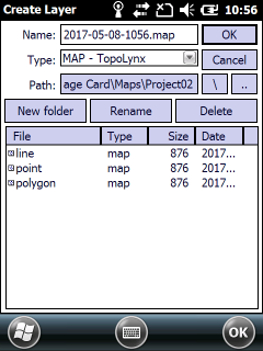
Supported formats on the Create Layer file panel:
- Vector: BNA, CRD, DAT, DGN, DXF, MAP, MIF/MID, SHP, ZIP(SHP)
- Tabular / Text: DBF, TAB, TXT
Default file name: today's date in YYYY-MM-DD-HHMM format
Default file format: MAP - TopoLynx
![]() For new users it is recommended to use the default MAP - TopoLynx file format to collect data in a vector layer. The layer can be easily exported with the
For new users it is recommended to use the default MAP - TopoLynx file format to collect data in a vector layer. The layer can be easily exported with the ![]() Save Layer command on the Layer Manager.
Save Layer command on the Layer Manager.
Supported vector formats with the New Layer command |
BNA - Atlas GIS |
CRD - Coordinates (point) |
DAT - Coordinates (shape) |
DGN - Microstation |
DXF - Autodesk |
MAP - TopoLynx |
MIF - Mapinfo Interchange |
SHP - ESRI Shape |
ZIP - Zipped ESRI Shape |
Supported tabular / text formats with the New Layer command |
DBF - dBase |
TAB - TopoLynx |
TXT - Text files |