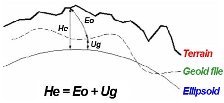
Geoid Separation File: This option will incorporate the geoid undulation in determining the orthometric elevation of the measurement. The definition of the geoid model as currently adopted by the National Geodetic Survey is the equipotential surface of the Earth's gravity field which best fits, in a least squares sense, global mean sea level. Orthometric elevation measurements are used in survey calculations. In order to convert ellipsoid heights (He) as measured by GPS into orthometric elevations (Eo), you must provide for a correction between the GPS-measured ellipsoid (reference ellipsoid) and a constant level gravitational surface, the geoid. This correction is the geoid undulation (Ug).
How to use Geoid Separation Files with TopoLynx topoXplore
1. Copy the Geoid Separation File(s) to the following directory:
Path:
Desktop version: |
$DOCUMENTS\TopoLynx topoXplore\Geoids |
Mobile version: |
$SDCARD\Geoids |
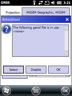
2. Tap on the ![]() Geoid File button on the Settings panel > GPS tab
Geoid File button on the Settings panel > GPS tab
3. Tap on the New button on the appeared message box to open the Geoid File panel
Geoid file selection message box
Deactivate - Deactivates the geoid file usage
Cancel - Closes the geoid file selection message box
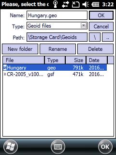
4. Select a geoid file
Geoid File selection panel
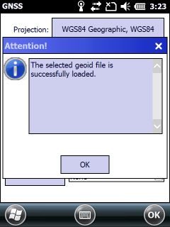
Successfully loaded geoid file
Supported geoid file formats:
•.DAT files
•.BIN files
•.GSF files
•.GGF files
•.GEO files
![]() You can download several geoid separation files here: http://resources.ashtech.com/GEOIDS
You can download several geoid separation files here: http://resources.ashtech.com/GEOIDS
![]() The selected geoid separation file can be applied on the Calculate panel in determining the orthometric elevation of the calculated position.
The selected geoid separation file can be applied on the Calculate panel in determining the orthometric elevation of the calculated position.