This dialog is accessible on the Online Data Sources tool to use online imagery content on the map view as WMS/WMTS/WFS and TMS services. The Connections tab contains the following controls:
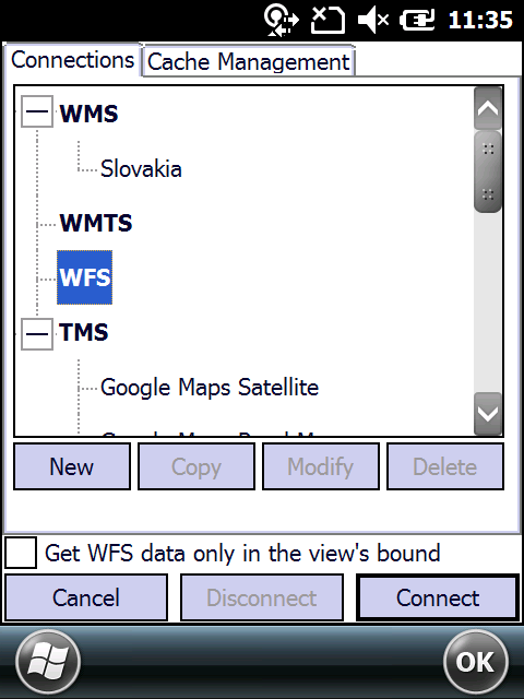
Online Data Sources - Connections tab
WMS/WMTS/WFS: Allows to add your own data sources for access to any data published on a WMS/WMTS/WFS server. The built-in WMS/WMTS/WFS client supports the WMS/WMTS/WFS server served map image data in bitmap format, e.g. PNG, GIF or JPEG or other formats.
Web Map Services
A Web Map Service (WMS) is a standard protocol for serving georeferenced map images over the Internet that are generated by a map server using data from a GIS database. The specification was developed and first published by the Open Geospatial Consortium in 1999.
Requests
WMS specifies a number of different request types, two of which are required by any WMS server:
•GetCapabilities - returns parameters about the WMS (such as map image format and WMS version compatibility) and the available layers (map bounding box, coordinate reference systems, URI of the data and whether the layer is mostly opaque or not)
•GetMap - returns a map image. Parameters include: width and height of the map, coordinate reference system, rendering style, image format
Request types that WMS providers may optionally support include:
•GetFeatureInfo - if a layer is marked as 'queryable' then you can request data about a coordinate of the map image.
•DescribeLayer
•GetLegendGraphic - return an image of the map's legend image, giving a visual guide to map elements
Web Map Tile Services
A Web Map Tile Service (WMTS) is a standard protocol for serving pre-rendered georeferenced map tiles over the Internet. The specification was developed and first published by the Open Geospatial Consortium in 2010.
Requests
WMTS specifies a number of request encodings:
•KVP (key-value-pairs) encoding
•REST (Representational state transfer) encoding
•SOAP (SOAP) encoding
The syntax for the WMTS request types is different for each of these encodings. Some request types are:
•Capabilities: returns information about the WMTS service parameters
•Tile: returns a map tile
•FeatureInfo: returns (alphanumeric) information for a given map location
•Legend: returns a legend image for the map
Web Feature Services
The Open Geospatial Consortium Web Feature Service Interface Standard (WFS) provides an interface allowing requests for geographical features across the web using platform-independent calls.
Data passed between a Web Feature Server and a client is encoded with Geography Markup Language (GML), an XML dialect which can be used to model geographic features.
The 1.0.0 version of the WFS specification requires the use of GML version 2.1.2, while the 1.1.0 version of the WFS specification requires the use of GML version 3.1.1. For both versions of the WFS specification, an arbitrary number of other encodings can also be defined, in addition to the required GML 2.1.2 or 3.1.1 format (for 1.0.0 and 1.1.0 respectively).
GML 2.1.2 contains encoding support for basic geometric 'primitives': points, lines, polygons, etc.
GML 3.1.1 contains encoding support for more advanced geometric representations: curves, surfaces, multi-dimensions (time, elevation, multi-band imagery). In addition, GML 3.1.1 includes encoding support for topologically integrated datasets.
WMS/WMTS/WFS list: displays the previously defined WMS servers listed below each other. Inactive if the Enable WMS option not checked.
Adding a WMS/WMTS/WFS layer to the map view: you can quickly add a WMS server data source to the map view as Background Map layer by selecting a WMS server list item here and then tap/click on the Connect button.
Removing a WMS/WMTS/WFS layer from the map view: click / tap on the Disconnect button.
New - Opens the WMS Server Management panel to define a new server
Copy - Copies the selected WMS/WMTS/WFS source as a new source (i.e.) to define a new layer set from the available data layers on the WMS Server Management panel
Modify - Opens the WMS Server Management panel to modify the parameters of the selected WMS/WMTS/WFS source
Delete - Removes the selected WMS/WMTS/WFS source from the list
[ ] Get WFS data only in view's bound - TopoXplore will check the bounds of the current map view and only requests and downloads features within these bounds - an options to save bandwidth and time.
TMS - Allows to use a built-in Tile Map Service source as a background map layer
Tile Map Services
Tile Map Service or TMS, is a specification for storing and retrieving cartographic data, developed by the Open Source Geospatial Foundation. The definition generally requires a URI structure which attempts to fulfill REST principles. The TMS protocol fills a gap between the simplistic standard used by OpenStreetMap and the complexity of the Web Map Service standard, providing simple urls to tiles while also supporting alternate spatial referencing system.
Supported Tile Map Server sources
•Google Maps Satellite
•Google Maps Topographic
•Google Maps Road
•Bing Maps Satellite
•Bing Maps Road
•Open Street Maps
•Nokia Maps Satellite
•Nokia Maps Road
•Nokia Maps Transit
•CloudMade Maps
•Open Sea Map
•Open Street Maps Polska
•Freemap Slovakia Road
•New Zealand Topographic Maps
Adding a TMS layer to the map view: select a TMS server option in the drop-down list and then tap/click on the Connect button
Removing a TMS layer from the map view: click / tap on the Disconnect button.
Cancel - Closes the panel
Disonnect - Removes any WMS/WMTS/WFS or TMS background map layer
Connect - Adds the selected WMS/WMTS/WFS or TMS server source to the current map view as a background map layer