The Data field panel contains the following controls:
The Data field panel
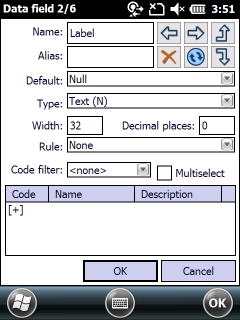
![]() - Shows the previous data field
- Shows the previous data field
![]() - Shows the next data field
- Shows the next data field
![]() - Moves the data field upwards in the Record panel
- Moves the data field upwards in the Record panel
![]() - Deletes the current data field
- Deletes the current data field
![]() - Refreshes the data field values when using a geometry type data field default value
- Refreshes the data field values when using a geometry type data field default value
![]() - Moves the data field downwards in the Record panel
- Moves the data field downwards in the Record panel
Name: Shows the editable name of the data field.
Alias: Shows the editable alias name of the data field. Default alias name is equal with the data field name. The alias data field name will be displayed on the Form view.
![]() The data field alias name can be stored in TopoLynx TAB file format and can be stored in TopoLynx topoXplore Map (.EXP) file in case of using other file formats.
The data field alias name can be stored in TopoLynx TAB file format and can be stored in TopoLynx topoXplore Map (.EXP) file in case of using other file formats.
Default: Shows the data field default value that will be used in case of record creation or creating/changing geometry
•Null: Field value will be zero/empty
•Copy last value: Field value will be the copy of the previous record value
•Copy nearest: Field value will be the copy of the nearest feature's record value
•Increment last value: Field value will be the increased value of the previous record
•Creation time: Field value will be equal to the creation time (the stored value depends on the operation system's time settings)
•GPS time: Field value will be the GPS Universal time
•Area of Geometry (m2): Field value will be the area of the geometry in square meter on geometry creation/modification
•Area of Geometry (ha): Field value will be the area of the geometry in hectare on geometry creation/modification
•Area of Geometry (ac): Field value will be the area of the geometry in acre on geometry creation/modification
•Area (custom): Field value will be the area of the geometry in current area unit on geometry creation/modification
•Perimeter of Geometry (m): Field value will be the perimeter of the geometry in meter on geometry creation/modification
•Perimeter of Geometry (km): Field value will be the perimeter of the geometry in kilometer on geometry creation/modification
•Perimeter (custom): Field value will be the perimeter of the geometry in current length unit on geometry creation/modification
•Length of Geometry (m): Field value will be the length of the geometry in meter on geometry creation/modification
•Length of Geometry (km): Field value will be the length of the geometry in kilometer on geometry creation/modification
•Length (custom): Field value will be the length of the geometry in current length unit on geometry creation/modification
•Distance to last object (custom): Field value will be
- the distance between two point features
- the distance between two line features (distance calculated between the center positions of the middle sections in the line feature)
- the distance of the center's positions between two polygon features in current length unit on geometry creation/modification
•Azimuth Angle: Field value will be the angle of the geometry on geometry creation/modification
•GPS heading: Field value will be the angle of the current GPS direction
•Speed (m/s): Field value will be the current calculated GPS speed in m/s
•Speed (custom): Field value will be the current calculated GPS speed in current speed unit
•Easting coordinate: Field value will be the X coordinate of the geometry on geometry creation/modification
•Northing coordinate: Field value will be the Y coordinate of the geometry on geometry creation/modification
•Latitude: Field value will be the Latitude coordinate of the geometry on geometry creation/modification
•Longitude: Field value will be the Longitude coordinate of the geometry on geometry creation/modification
•Altitude: Field value will be the height of the geometry = Mean Sea Level (MSL) if a geoid separation value is specified
•Height above ellipsoid: (HAE) Field value will be the height above the ellipsoid
•Satellites in use: Field value will be the number of used satellites
•Satellites in view: Field value will be the number of viewable satellites
•PDOP value: Field value will be the PDOP value
•Horizontal error: Field value will be the horizontal RMS error (horizontal positioning error)
•Vertical error: Field value will be the vertical RMS error (horizontal positioning error)
•DGPS fix rate: Field value will be the ratio of the DGPS fix positions (in percent) proportion to uncorrected positions
•PPS fix rate: Field value will be the ratio of the PPS fix positions (in percent) proportion to uncorrected positions
•FloatRTK rate: Field value will be the ratio of the FloatRTK positions (in percent) proportion to uncorrected positions
•FixRTK rate: Field value will be the ratio of the FixRTK positions (in percent) proportion to uncorrected positions
•Differential Correction Age: Field value will be the differential correction age
•Correction type: Field value will be the ratio of differentially corrected positions (in percent) proportion to corrected positions (e.g. 70% Autonomous, 30% DGPS)
•Measure reliability: Reliability value calculated by the PDOP values
•Measure limit: Reliability limit calculated by the measured area
•Measure identifier: Field value will be a unique identifier of the primary measured feature during the GPS data capture. Required when you collect attributes for vertices in a ![]() point info layer
point info layer
•Unique identifier (GUID): Field value will be a GUID unique identifier of the primary measured feature during the GPS data capture. Required to use it in multi-user environment instead of the Measure identifier default field value. Required when you collect attributes for vertices in a ![]() point info layer
point info layer
•Username: Field value will be the logged in user to the LOGIN module. (The LOGIN module is an optional module to TopoLynx topoXplore, can be purchased additionally.)
![]() The data field default value can be stored in TopoLynx TAB file format and can be stored in the TopoLynx topoXplore Map (.EXP) file in case of using other file formats.
The data field default value can be stored in TopoLynx TAB file format and can be stored in the TopoLynx topoXplore Map (.EXP) file in case of using other file formats.
Type: Shows the data type of the field.
•Logical: 1 byte length logical (true/false) value
•Byte: 1 byte length integer value. Value range: 0..255
•Short integer: 2 byte length integer value. Value range: -32768..32767
•Long integer: 2 byte length integer value. Value range: -2147483648..2147483647
•Float: 4 byte length real value provides up to 7 decimal digits
•Double: 8 byte length real value provides up to 15 decimal digits
•Date: 4 byte length date with minute precision
•Time: 8 byte length date with 1/10000 second precision
•Text: Character field without size limit
![]() The maximum character size to Text field type is 254 character in DBF file format (to ESRI Shape files).
The maximum character size to Text field type is 254 character in DBF file format (to ESRI Shape files).
•Document: This type stores a path or URL of an object (image, sound, document) by using the Document panel
Width: Shows the number of the characters to the field name in case of fixed record size formats (DBF, TAB)
![]() The maximum field name width is 11 character in DBF file format (to ESRI Shape files)
The maximum field name width is 11 character in DBF file format (to ESRI Shape files)
Decimal places: Number of decimals to display real values
Rule: Verification procedure after each modification of the field value
None: No verification
Read only: The cell value cannot be modified. Recommended for calculated fields
Not null: The cell value cannot be null
Unique value: The cell value cannot be repeated, must be unique in the table
Range: The cell value must be in a given range (between minimum and maximum)
Valid value: The cell value must be an existing value of the data field
Code filter: Filters the selectable codes from the code dictionary based on the geometry or data filed names
![]() The data field alias name can be stored in TopoLynx TAB file format and can be stored in TopoLynx topoXplore Map (.EXP) file in case of using other file formats.
The data field alias name can be stored in TopoLynx TAB file format and can be stored in TopoLynx topoXplore Map (.EXP) file in case of using other file formats.
List: Shows the defined code set of the code dictionary to the current data field