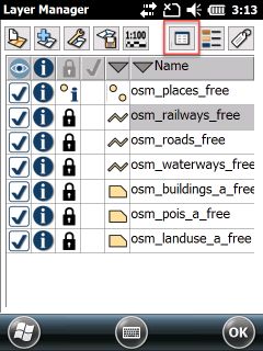
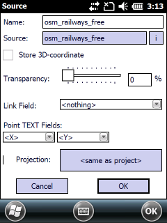
The Source panel is used to configure some options that are specific to each layer in your map. You can access the Source panel by tapping the Source button in the Layers panel. This panel contains the same controls for vector layers, text and tabular files. The layer properties for raster layers can be found in the next topic.
Open the Source panel to the selected vector layer


Name: The layer's name can be edited which will be displayed in the Layers panel. The default name of the layer is equal with the Source name.
Source: Displays the data source of the layer. TopoLynx topoXplore stores relative path to the TopoLynx topoXplore Map file (.EXP).
Link field: In Tree view the records of the related table connect to the parent table by the value of this selected data field. The default is "<nothing>".
X position field: Select the data field which stores the X (horizontal) coordinates of the point. The default is "<nothing>"
Y position field: Select the data field which stores the Y (vertical) coordinates of the point. The default is "<nothing>"
![]() X position field and Y position field can be applied with a text file layer to create a point feature layer
X position field and Y position field can be applied with a text file layer to create a point feature layer
![]() TopoLynx topoXplore can display the selected X,Y positions from a text or tabular file as a point layer on the map.
TopoLynx topoXplore can display the selected X,Y positions from a text or tabular file as a point layer on the map.
The Transparency feature is used to specify the transparency settings for the vector layer. The layer transparency can be specified for the vector and raster layers.
Use the slider to specify the amount of transparency for the entire layer. Transparency can range from 0% (i.e. opaque, or no transparency) to 100% (i.e. completely transparent).
The default is 0%, i.e. opaque or no transparency.
Storing 3D coordinates: Enables to store 3D coordinates (X,Y,Z) in the edited layer when using the supported vector layer formats. 3D geometry (X, Y, Z) can be a point and also a vertex in a polyline or polygon feature. When using the GNSS Survey panel TopoLynx topoXplore stores the Z coordinate as a measured value.
oOn the Source dialog of the layer you can enable to store Z coordinates in the geometry to an existing vector layer
oOn the New layer panel (at layer creation) you can enable to store Z coordinates in the geometry to the new vector layer
oHeight (Z) coordinates of the geometry can be viewed on the Geometry panel
oHeight (Z) coordinates of the geometry can be edited on the Existing Vertex panel
![]() The Storing 3D coordinates option is enabled after adding supported vector layers only when there is minimum one point, polyline or polygon feature geometry with Height value in the geometry.
The Storing 3D coordinates option is enabled after adding supported vector layers only when there is minimum one point, polyline or polygon feature geometry with Height value in the geometry.
Vector information: Displays the number of fields, records, the geometry precision and the amount of allocated memory
This layer is in SRS: Active only when the .dtproj file exists next to the layer. Please not that the .dtproj file will be removed when you uncheck this option.
OK - Saves the modification you have made on this panel and closes the panel.
Undefined - Opens the Select Projection dialog to set the known projection of the layer then displays the selected projection on this button. When adding a new layer to the map view TopoLynx topoXplore assumes that its spatial reference system (SRS) is identical with the map view's SRS. When you select the known SRS to the layer on this panel TopoLynx topoXplore on-the-fly transforms it into the map view's SRS and writes a .dtproj file next to the layer file. When the .dtproj file exists next to the layer it is Identified and you can see its projection parameters on this button.
Cancel - Closes the Source panel
![]() The source settings of the vector layers can be stored in the TopoLynx topoXplore Map file (.EXP) or TopoLynx Map Pack file (.DMP) formats.
The source settings of the vector layers can be stored in the TopoLynx topoXplore Map file (.EXP) or TopoLynx Map Pack file (.DMP) formats.